Pakistan launches high-resolution imaging satellite deployment
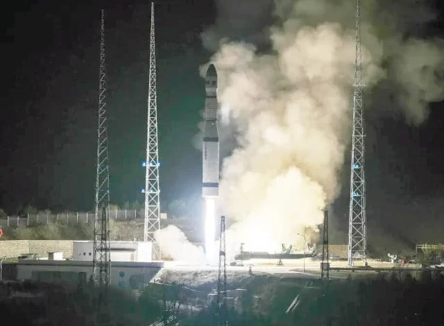
On Saturday, China successfully launched a Pakistani remote sensing satellite from the Taiyuan Satellite Launch Center in Shanxi province, according to state-run Xinhua News.
The satellite, designated PRSC-EO3, was launched into orbit by a Long March-6 rocket at 8:15 PM (1215 GMT).
It has successfully achieved its designated orbit, as per official sources.
The launch signifies the 640th flight of China’s Long March rocket series, an essential element of the nation’s burgeoning space program.
PRSC-EO3 is anticipated to enhance Pakistan’s Earth observation capabilities, encompassing the monitoring of natural resources, disaster management, and environmental alterations.The Pakistan Space and Upper Atmosphere Research Commission (Suparco) has successfully launched its indigenous electro-optical satellite (EO-3) from the Taiyuan Satellite Launch Centre, representing a notable advancement in the country’s space capabilities,” stated the Foreign Office in a message shared on the social media platform X.In addition to its primary imaging function, EO-3 accommodates sophisticated experimental payloads designed to validate next-generation space technology. These comprise a multi-geometry imaging module for improved imaging precision, an upgraded energy storage system, and an onboard AI-driven data processing unit to facilitate real-time analysis and intelligent decision assistance,” it stated.
The inclusion of EO-3 in Pakistan’s Earth Observation satellite fleet “substantially improves national competencies in remote sensing”.The integrated system would enhance data continuity, imaging reliability, and analytical precision, facilitating applications throughout Pakistan’s socio-economic sectors,” stated the Foreign Office.
The military’s media affairs division, Inter-Services Public Relations, stated that the satellite would furnish image data to “transform urban planning, disaster management, food security, and environmental protection.”
President Asif Ali Zardari characterised the event as a “historic milestone” in a statement.
He emphasised that it was a “distinct demonstration of Pakistan’s self-sufficiency, scientific proficiency, and advancing capacity in space technology.”
The president commended the professional proficiency of Suparco’s scientists and engineers, stating that their endeavours were aligning Pakistan with contemporary demands.
The president praised China’s “reliable and steadfast collaboration” in the space domain.
Prime Minister Shehbaz Sharif praised the scientists and engineers of Suparco for their accomplishment, as stated in the FO release.He reiterated the government’s robust dedication to enhancing Pakistan’s space program and conveyed gratitude for China’s ongoing collaboration in this area,” it stated.
The deployment of the EO-3 satellite signifies a significant advancement in Pakistan’s quest for self-sufficiency and technological progress in the space domain. The satellite, endowed with sophisticated imaging capabilities, is anticipated to significantly influence urban planning, disaster management, food security, and environmental protection nationwide.
Officials stated that the EO-3 satellite will establish the groundwork for a comprehensive Earth Observation System, designed to support national priorities across several sectors and foster sustainable socio-economic growth.